
Shawnee Neighbors by Block
Public sources can explain a Shawnee block in layers. The parcel map identifies nearby polygons and their property fields. The tax and deed systems add ownership and transfer information. Election records can provide date-bounded registration information only through the authorized public route, with protected classes removed. Historical collections may place an earlier household at an address. None of those sources supplies a full list of your neighbors, and each has a different date and purpose. Label the result as parcel owner, historic address lead, public registration record, or resident confirmed by a proper source.
| Shawnee block source | What it can show | Access and limit |
|---|---|---|
| City_Property polygons | Parcel boundary, owner field, property address, geometry | Public REST and map service; no household roster |
| County tax and deed records | Owner, situs and mailing distinction, legal description, transfer history | Portal or County Clerk; ownership is not occupancy |
| Public voter request route | Ordinary public registration and precinct context | Election Board or Data Warehouse procedure; privacy rules apply |
| Library and OHS collections | Historic occupants, address clues, events, and newspapers | Microfilm, Research Center, or approved historical collections |
| Community rosters | Potential civic contact information | No verified public Shawnee association directory was located |
A tax mailing address may belong to an owner who is elsewhere. A recorded party may be a trustee, executor, lender, or agent. A public map's OWNER field needs the same caution. For Shawnee neighbors, record “parcel owner located” and “resident confirmed” as different statuses. That small distinction is the best protection against assigning a person to the wrong block.
Map Shawnee Parcels First
The City of Shawnee City_Property layer is the starting point for the immediate block. Its polygon features include Parcel_ID, OWNER, Property Address, Documents, descriptive fields, geometry, area, and length. The ArcGIS service supports Identify, Query, pagination, distance, SQL, ordering, and attachments. Related services cover Lots, Plats, Blocks, CityLimits, Roads, Zoning, cemetery layers, and other civic geography.
The City_Property parcel-layer schema shows the Shawnee fields available for a nearby-parcel check.
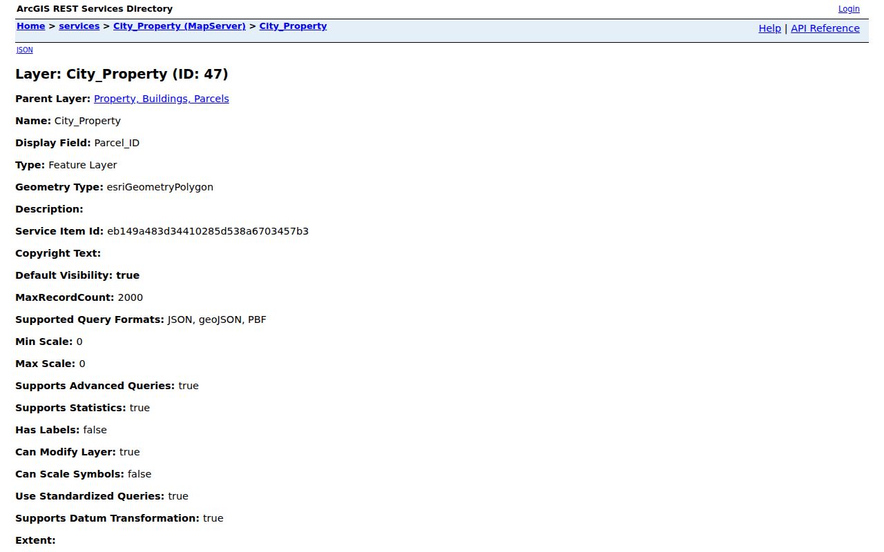
The sample fields make the limitation plain: a feature can have a governmental owner or blank descriptive fields. The service reported a 2,000-feature maximum per query, so broad extraction needs pagination or a narrow query. It should never be treated as a list of Shawnee neighbors.
CityLimits, Roads, and Zoning add useful context to a Shawnee neighbor check. They can show whether a parcel sits near a municipal edge, public right-of-way, or zoning boundary. They cannot identify household members or delivery recipients. A nearby cemetery layer is a place and record-keeping context, not evidence that anyone lives on the parcel.
Map a Shawnee Neighbor Block
Use a parcel's geometry rather than a rough sequence of street numbers. A street can have a road, alley, access strip, or oddly shaped lot between two numbered addresses. City GIS supports spatial and distance queries, while Lots, Plats, Blocks, and Roads help distinguish a neighboring polygon from nearby but non-adjacent land. Save the distance, units, spatial relationship, and query condition used for every set of adjacent features.
- Find the target Shawnee property by Property Address or Parcel_ID in City_Property and retain the returned parcel key.
- Use the polygon geometry with the map's browse tools or supported spatial query to select nearby parcels, not merely similar street numbers.
- Check Lots, Plats, Blocks, Roads, CityLimits, and Zoning to understand whether the selected geometry is a lot, street frontage, boundary feature, or tax parcel.
- Cross-check each parcel with the County Treasurer or Assessor and the County Clerk deed index, retaining owner information separately from any resident confirmation.
For the longer chain along a named road, the Shawnee Street Directory takes the address work beyond the immediate block. The block method stays focused on the polygons immediately surrounding one property.
Shawnee Owners Need Cross-Checks
The Pottawatomie tax search accepts owner name, address, street name, Treasurer's Parcel Number, CAMA or appraiser parcel number, and section, township, and range fields. The County Clerk's OKCountyRecords index adds party roles, instrument number, recorded date, legal description, addition, block, and lot. Online land-record indexes and images begin in January 1985. Earlier work moves to Kofile QuickLink, the clerk counter, plat books, microfilm, or the OHS and library research channels.
A parcel owner can be a trust, estate, company, agency, or person with a different mailing address. A deed party can be a grantor, grantee, trustee, lender, mortgagee, releasee, or agent. The property trail can support a carefully dated ownership statement, but it does not identify all Shawnee neighbors who use or occupy nearby addresses.
Note: Compare the full legal description and lot, block, or addition fields before treating two nearby parcel records as the same property.
Voter Records Do Not Map Neighbors
Oklahoma's public voter-data notice describes ordinary registration fields such as name, date of birth, county, residence or mailing information, party affiliation, precinct, municipality, registration date, and election dates or method. The OK Voter Portal, however, is a verification form that requires first name, last name, and date of birth. It does not promise a public street-by-street search. A defined public-file or historical request follows Election Data Warehouse and Open Records procedures instead.
The Pottawatomie County Election Board manages registration, precinct, and election files. The state request guidance asks for a reasonably specific timeframe, record, and term, and the agency does not need to create a new report. Restricted-record voters and Address Confidentiality Program participants must not be inferred from a sparse block. Less visible data can mean a protected record or a limit in the search route, not an empty household.
Shawnee Neighbor Sources Have Gaps
No verified public Oklahoma directory of Shawnee neighborhood associations, membership lists, or private community rosters was found in the source review. That absence is important. Do not replace it with unverified social groups or scrape private membership lists. Public meeting notices, approved historical collections, and direct contact with a known custodian are safer routes for civic context around Shawnee neighbors.
Neighborhood associations
No official Shawnee association directory or public roster was verified. Use the City of Shawnee entry point for official public information and confirm any association contact with its custodian.
Historical Society Museum
Pottawatomie County Historical Society and Museum, 207 N Minnesota, Shawnee, lists local history access and possible artifact or manuscript leads. Private membership data is not a public block list.
Shawnee Public Library
Shawnee Public Library, 101 N Philadelphia, offers reference access. Its microfilm and librarian help can support dated historical research, while patron records remain private.
The City of Shawnee official entry page is the verified local source used when no public association directory could be confirmed.
The lack of a verified roster protects against treating private community participation as a public record. Use public history and meetings for context, not for a list of households.
For older Shawnee neighbors, a librarian or museum staff member may help identify a dated newspaper, directory, map, or artifact collection. Ask for a year, street, subdivision, or family name and retain the collection reference. A historical civic mention can establish context, but it should not be converted into a current contact record.
Sheriff Records Are Not Neighbor Lists
The Pottawatomie County Sheriff page provides official contact, records-request, offender-watch, and victim-advocate information. No verified official county inmate-roster search URL was found. When a defined incident, booking, citation, or response record is needed for a lawful purpose, use the Sheriff's request form and give a specific date range, location, and record category. Ask for statutory redactions and a segregable copy if only part of a record can be released.
The Sheriff's official records entry point is a custodian route, not a tool for compiling a block list.
An incident entry, warrant notation, or registry result does not establish wrongdoing, current address, or a reason to contact someone. Confirm any record with the agency and its case context.
Shawnee Neighbor Source Comparison
Official records are dated, jurisdiction-specific, and tied to a custodian. Commercial neighbor tools are a category of services that can combine purchased files, public-record data, and uncertain name-address matches. They may be stale or wrong and are not an authority for a protected or current location. Use the official source first, retain the date, and seek custodian confirmation before relying on a match.
| Source type | Useful for | Key limit |
|---|---|---|
| Official parcel and deed records | Dated parcel ownership and legal description | Owner or party is not automatically a current resident |
| Official election and request routes | Authorized, date-bounded registration context | Restricted classes and confidential fields are protected |
| Commercial neighbor tools | A lead that needs independent verification | Can combine stale or mismatched data and should not override a custodian |
When the goal is simply to understand the block, a small record trail is enough: address, Parcel_ID, ownership date, and the custodian used. Keep any public-name result out of a casual block list until a second independent record supports it. That approach leaves room for privacy protections and ordinary changes in ownership or occupancy.
Privacy Limits for Shawnee Neighbors
Oklahoma law protects more than a parcel map shows. Other household members, utility customers, delivery recipients, driver information, vital records, protected voters, and Address Confidentiality Program participants are not a public block directory. The Open Records Act allows access subject to exemptions and reasonable procedures. It does not authorize reversing a substitute address, publishing sensitive details, or turning a partial result into a neighborhood profile.
Lawful use. Use Shawnee neighbor records for legitimate personal research, civic context, or a documented property question. Do not stalk, harass, intimidate, or attempt to expose any protected person.